South Korea Satellite Imagery Services Market Size, Share, and COVID-19 Impact Analysis, By Type (Ground Equipment, and Services), By End User (Maritime, Defense and Government, Enterprises, Media & Entertainment, and Others), and South Korea Satellite Imagery Services Market Insights Forecasts to 2033
Industry: Electronics, ICT & MediaSouth Korea Satellite Imagery Services Market Insights Forecasts to 2033
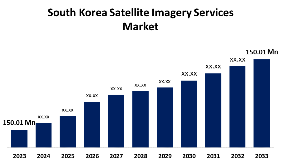
- The South Korea Satellite Imagery Services Products Market Size Was Valued at USD 150.01 Million in 2023.
- The Market Size is Growing at a CAGR of 10.89% from 2023 to 2033
- The South Korea Satellite Imagery Services Products Market Size is Expected to Reach USD 421.89 Million by 2033
Get more details on this report -
The South Korea Satellite Imagery Services Products Market Size is Anticipated to Exceed USD 421.89 Million by 2033, Growing at a CAGR of 10.89% from 2023 to 2033.
Market Overview
Satellite imagery is the act of acquiring visual information of the Earth's surface from spacecraft circling around our planet. These satellites are fitted with specialized cameras and sensors that take high-quality images of the Earth's surface, which are later sent to Earth for examination. The images can vary from panchromatic to multi-spectral images that capture a broad range of data. Aerial photography and mapping services are extensively employed in urban planning, real estate, agriculture, and infrastructure development industries. High-quality aerial images offer important information for creating maps, 3D models, and visual representations that are crucial for making decisions and planning projects. South Korea is famous for its technological progress, and the field of imaging services is no different. The nation has seen the advancement of high-resolution satellite images, drones fitted with advanced cameras, and LiDAR technology, allowing for more precise and detailed mapping and surveying. In December 2022, South Korea responded to North Korea's imagery of Seoul by releasing a photo of Pyongyang taken from its own satellite. The high-resolution photo, released from the land satellite No. 1, displays Kim Il-sung Square and its surrounding landmarks such as a history museum, an art museum and a department store.
Report Coverage
This research report categorizes the market for South Korea satellite imagery services market based on various segments and regions and forecasts revenue growth and analyzes trends in each submarket. The report analyses the key growth drivers, opportunities, and challenges influencing the South Korea satellite imagery services market. Recent market developments and competitive strategies such as expansion, product launch, and development, partnership, merger, and acquisition have been included to draw the competitive landscape in the market. The report strategically identifies and profiles the key market players and analyses their core competencies in each sub-segments of the South Korea satellite imagery services market.
South Korea Satellite Imagery Services Market Report Coverage
| Report Coverage | Details |
|---|---|
| Base Year: | 2023 |
| Market Size in 2023: | USD 150.01 Million |
| Forecast Period: | 2023 - 2033 |
| Forecast Period CAGR 2023 - 2033 : | 10.89% |
| 2033 Value Projection: | USD 421.89 Million |
| Historical Data for: | 2019-2022 |
| No. of Pages: | 190 |
| Tables, Charts & Figures: | 115 |
| Segments covered: | By Type, By End User |
| Companies covered:: | Dtonic Corporation, Bentley Systems, Inc., Dabeeo Inc., General Electric (GE), ESRI Inc., Soletop, InSpace Co., Ltd., GBS Korea, Maxar Technologies, L3Harris Corporation Inc., and Others |
| Pitfalls & Challenges: | COVID-19 Empact, Challenge, Future, Growth, & Analysis |
Get more details on this report -
Driving Factors
Satellite imaging services are vital for the military and defense operations of South Korea. By offering crucial information to South Korean military intelligence agencies. It enables them to observe and analyze events in neighboring nations, specifically North Korea. Satellite images are useful for pinpointing military bases, detecting missile launches, monitoring troop movements, and evaluating changes to infrastructure. Satellites fitted with advanced imaging sensors are able to gather up-to-the-minute visuals, allowing the South Korean military to surveil key areas like sensitive border regions and disputed territories. This data contributes to keeping track of the situation, recognizing possible dangers, and organizing military missions.
Restraining Factors
The development and maintenance of satellite technology can be prohibitively expensive, limiting access for smaller companies and organizations.
Market Segment
The South Korea satellite imagery services market share is classified into type and end user.
- The services segment is expected to hold the largest market share through the forecast period.
The South Korea satellite imagery services market is segmented by type into ground equipment, and services. Among these, the services segment is expected to hold the largest market share through the forecast period. This can be mostly attributed to the increasing need for data analytics, processing, and specialized applications in different sectors like agriculture, urban planning, and environmental monitoring. The services segment is becoming a crucial focus area for companies in the market due to the growing importance of actionable insights obtained from satellite data.
- The defense and government segment is expected to hold the largest market share through the forecast period.
The South Korea satellite imagery services market is segmented by end user into maritime, defense & government, enterprises, media & entertainment, and others. Among these, the defense and government segment are expected to hold the largest market share through the forecast period. This is mainly because government and military organizations are increasingly needing surveillance, reconnaissance, and intelligence gathering.
Competitive Analysis:
The report offers the appropriate analysis of the key organizations/companies involved within the South Korea satellite imagery services market along with a comparative evaluation primarily based on their product offering, business overviews, geographic presence, enterprise strategies, segment market share, and SWOT analysis. The report also provides an elaborative analysis focusing on the current news and developments of the companies, which includes product development, innovations, joint ventures, partnerships, mergers & acquisitions, strategic alliances, and others. This allows for the evaluation of the overall competition within the market.
List of Key Companies
- Dtonic Corporation
- Bentley Systems, Inc.
- Dabeeo Inc.
- General Electric (GE)
- ESRI Inc.
- Soletop
- InSpace Co., Ltd.
- GBS Korea
- Maxar Technologies
- L3Harris Corporation Inc.
- Others
Key Target Audience
- Market Players
- Investors
- End-users
- Government Authorities
- Consulting and Research Firm
- Venture capitalists
- Value-Added Resellers (VARs)
Recent Development
- In April 2024, South Korea has effectively put its second military surveillance satellite into space, shortly after North Korea restated its intention to launch several reconnaissance satellites in the same year. Last year, North Korea and South Korea both sent their inaugural spy satellites into space in November and December respectively, during a period of increased tensions between the two nations. They claimed their satellites would increase their monitoring capabilities of each other and improve their missile attack abilities.
Market Segment
This study forecasts revenue at regional, and country levels from 2022 to 2033. Spherical Insights has segmented the South Korea satellite imagery services market based on the below-mentioned segments
South Korea Satellite Imagery Services Market, By Type
- Ground Equipment
- Services
South Korea Satellite Imagery Services Market, By End User
- Maritime
- Defense & Government
- Enterprises
- Media & Entertainment
- Others
Need help to buy this report?